Lot 114
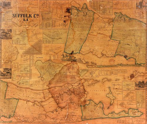
Suffolk Cty Long Island Smith Chace Wall Map 1858
Estimate: $400 - $600
Bid Increments
| Price | Bid Increment |
|---|---|
| $0 | $10 |
| $100 | $25 |
| $400 | $50 |
| $1,000 | $100 |
| $3,000 | $200 |
| $5,000 | $500 |
| $10,000 | $1,000 |
| $20,000 | $2,500 |
| $50,000 | $5,000 |
| $100,000 | $10,000 |
Jacob Chace Jr., co published by Robert Pearsall Smith and John Douglass, Map of Suffolk County, Long Island, From Actual Surveys, 1858, hand colored lithograph, printed on 4 conjoined sheets now mounted to Masonite, 48.5 x 57.5 inches, in a wood frame 53.5 x 62.5 inches. Often considered to be the most detailed map of Suffolk County printed in the 19th century. Includes an extraordinary level of detail, with the name of every plot, business and civic building in the county. Includes inset plans of Southampton, Easthampton, Sag Harbor, Amityville and many others in and around the Hamptons. A rare map, often found with significant condition issues.
In fair condition, with a large stain to the bottom center and another smaller area of darker staining to the upper center; stabilized cracking throughout; general age toning and the hand coloring has faded; scattered small areas of loss, especially to the center; still presentable, but worn. Merchandise will be packed and transported by the purchaser at their own risk and expense. A list of recommended shippers is on our website: https://www.conceptgallery.com/auctions/shipping/ .
Condition
Concept Gallery does not pack and ship. A list of packers and shippers that regularly visit our gallery is available on our website http://conceptgallery.com/auctions/shipping/. All property must be paid in full before we will release your purchases to the shippers. Please note that you will not see a charge for shipping on our invoice to you as all of our shipping is done by third parties.


